BCS Annual Conference
The in-person, two-day event, has run nearly every year since 1963


2026 ANNUAL CONFERENCE
Registers of Scotland, Meadowbank House, London Road, Edinburgh
(Photo ID required to access building on the day)
Tuesday 8th - Wednesday 9th September 2026
A two day event that includes a GeoViz Workshop at Registers of Scotland followed by a visit to the National Collection of Aerial Photography (NCAP) and the Map Curators' (MCG) 60th Anniversary Workshop at the National Library of Scotland (NLS), both on Tuesday 8th September. The main conference, including the BCS Awards ceremony at the Registers of Scotland on Wednesday 9th September.
Venues
Registers of Scotland, Meadowbank House, 153 London Road, Edinburgh EH8 7AU
National Library of Scotland, George IV Bridge Edinburgh EH1 1EW
National Collection of Aerial Photography, Historic Environment Scotland Unit 3, Seven Hills Business Park 41 Bankhead Crossway South Edinburgh EH11 4EP


Detailed Programme
British Cartographic Society Annual Conference and Map Curators' Workshop, at
Registers of Scotland (RoS), Meadowbank House, London Road, Edinburgh and other
locations, (Photo ID required to access RoS building on the day)
Tuesday 8th September 2026
Geoviz Workshop at RoS and National Collection of Aerial Photography visit
10.00 - 12.00 GeoViz Workshop at RoS on the art and science of communicating with data (see below)
12.00 - 13.00 Sandwich lunch at RoS
13.00 - 14.00 Travel to NCAP
14.00 - 16.00 Tour of National Collection of Aerial Photography (see below). Limited places
Tuesday 8th September 2026
Map Curators' Conference at NLS
10.00 - 17.30 MCG 60th Anniversary Workshop including the inaugural Ann Sutherland lecture (see below)
Dinner
Dinner at the Edinburgh Street Food restaurant ten minutes walk from Waverley Station, multiple food outlet options to choose from with each diner making their own food and drink choices and individual payment.
Wednesday 9th September 2026 at RoS
Programme (subject to change)
THEME: Education, Economy and Environment – where does cartography fit in?
09.00 - 09:30 Registration and Networking with coffee
09:30 - 09:40 Welcome and format of the day
Session 1: How maps can enhance our understanding of data
09:40 - 10:20 The Scottish Government Design System – Maps in Public Services by Liam Mason
Beyond Visualisation: Maps as Analytical Systems in the Age of AI by Kathryn Berger
10:20 - 11.10 Coffee & Speed Networking - – get to know each other in a semi-formal session, background, employment, career, etc.
Session 2: The use of geospatial technologies and cartography in education
11:10 - 12.10 Research-Led Geomatics Education in the Age of GeoAI: From Map-Making to Visual Reasoning by Mingshu Wang
Reflections on the GeoSpatial Curriculum by Bruce Gittings
Fife College’s Geospatial Foundation Skills Programme by Lauren Miller
12.10 - 13.00 AWARDS
13.00 - 14.00 Lunch & Networking - Meet our sponsors
Session 3: Mapping and its role in the economy
14.00 - 14.40 Modernising the mapping of Scotland’s land and property rights by Alastair Reid
Atlas of Finance: Process and Message by Dariusz Wojcik & James Cheshire
14.40 - 15.40 Industry insights, opportunities and advice – three way options
1. CV Clinic (BCS Student Members Only)- discussions and advice provided to applicants and by employers
2. Panel session general Q & A “Geography and Cartography – Geofutures Outcomes”
3. Geovation Scotland (funded by RoS) - showcase of early stage start up companies in land, property and location in Scotland
15.40 - 15.50 Comfort break
Session 4: Leisure, nature and the environment - where maps fit in
15.50 - 16.50 Accessibility inequalities to everyday facilities among social groups in Edinburgh’s 20-minute neighbourhoods: insights from Melbourne by Dr Zhiqiang Feng
The Journey Matters, 50 years of Independent Mapping by Adam King
16.50 - 17.00 Closing Remarks BCS President
Map Curators’ Group 60th Anniversary Workshop Tuesday 8th September 10.00 - 17.30
The Map Curators’ Group will celebrate its 60th anniversary by hosting a workshop at the National Library of Scotland (NLS) in Edinburgh on Tuesday 8th September, from 10am until 5.30pm.
The morning session will see the group visit the Map Library in the Causewayside building, where there will be opportunity to tour the library facilities, view a collection of early maps of Scotland, and hear about recent work at the library, including its events and digitisation. After a lunch break, we will reconvene at the main NLS building on George IV Bridge for a series of talks. Among these will be a talk in memory of the former long-serving MCG convenor, Ann Sutherland. Ann was a keen advocate of international cooperation within the map library profession, and we hope that this will be the first time of many that we will be able to invite an overseas speaker to an MCG event in this way.
Our inaugural Ann Sutherland Lecture will be given by Marcy Bidney; Assistant University Librarian for Distinctive Collections at the University of Chicago in the United States. Marcy is also chair of the worldwide Map and Geospatial Information Curators Group (MAGIC), and her talk will reflect on Ann Sutherland’s legacy of internationalism, exploring how cross-border collaboration continues to shape professional identity in our field.
The Map Curators Group is open to anyone interested in the preservation, dissemination and use of maps in libraries and archives, and we hope that you will be able to join us for this exciting workshop as we mark our 60th anniversary.
Geoviz Session Tuesday 8th September 9.30 - 13.00
The first morning features a lively two-hour Geographic Visualisation session on the art and science of communicating with data. You’ll start with core design principles for creating clear and impactful visuals, followed by a fun, collaborative, laptop-free exercise in visual journalism. Working in small groups, you’ll sketch maps and data visuals to tell real-world stories. No technical skills or preparation required, just bring creativity and enthusiasm. Facilitated by Liam Mason (Scottish Government) and Paul Naylor (BCS President).
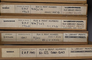
Visit to National Centre for Aerial Photography Tuesday 8th September 14.00 - 16.00
The National Collection of Aerial Photography (NCAP), based in Edinburgh is a part of Historic Environment Scotland. It holds one of the most significant collections of aerial photography in the world with over 30 million images, providing a detailed and unique perspective on key moments in world history dating back over 100 years to 1924 when the oldest images were taken and covering over 170 territories.
The collection has been assembled from multiple sources including British Aerial Survey Firms, DOS. DGC. Allied Central Interpretation Unit, Environment Agency, JARIC, National Archives, NERC and others. The images collected and stored go through a series of processes including collections care, digital imaging, cataloguing and access and data management. And to ensure maximum access for the public, web services have been developed to provide mapping tools to zoom into areas of interest and explore tens of thousands of images.
The current modern facility was opened in 2020 for the specialised purpose of managing, digitising and processing millions of historic aerial images with complex collections care needs. Over the coming months a vast collection of already-digitised imagery is to be made available online. This will give users faster and easier access to an unprecedented volume of aerial photography.
The tour of the facilities will last approximately two hours and will visit each part of the operation from raw images through to the products and services made available through the website. The highlight will be the pioneering robotic digitisation which it is estimated that using traditional methods of manually scanning of the holdings would take over 300 years. NCAP, implemented using R&D. now utilizes custom-designed robotic "cobots" (collaborative robots) to accelerate the digitization of millions of historical aerial photographs, scanning over 1,500 images daily. This automated system, which operates 24/7, safely handles fragile, large-scale collections, such as the 1.7 million Directorate of Overseas Surveys (DOS)